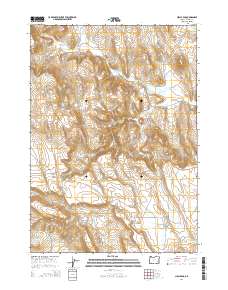
2014 Map of Circle Bar
USGS Topo · Published 2014About this map
Circle Bar and the elevated terrain of Beaver Tables define this high desert landscape in Harney County. The area is marked by a network of drainage systems and early water management efforts, including the Fister Ditch which diverts water toward the basin. The movement of water is central to the land's utility, with Crane Cr and Beaver Cr winding through the valley floor alongside the winding route of Crane Venator Ln. Historically significant as a ranching corridor, the map reveals the complex hydrography of the region through its various branches like Little Beaver Cr and Little Crane Cr. The township and range lines indicate a strictly organized landscape where large tracts of land are punctuated by these vital seasonal and perennial water sources, reflecting the enduring rural character of southeastern Oregon.
Find a feature on this map
16 named features on this map. Tap any name to fly to it.
Don’t see what you’re looking for? This feature index may not catch every label — zoom into the map to look around manually.
Map Details
Editions of this 2014 Circle Bar Map
This is the sole edition of this map. No revisions or reprints were ever made.
Other maps of this area

1955 · Burns
USGS Topo · 1:250,000

1958 · Burns
USGS Topo · 1:250,000

1959 · Burns
USGS Topo · 1:250,000

1960 · Crane
USGS Topo · 1:62,500

1967 · Adobe Flat
USGS Topo · 1:24,000

1968 · Venator
USGS Topo · 1:62,500

1972 · Circle Bar
USGS Topo · 1:24,000

1972 · Venator
USGS Topo · 1:24,000
1972 · Dunnean
USGS Topo · 1:24,000
1972 · Tin Can Ridge
USGS Topo · 1:24,000