
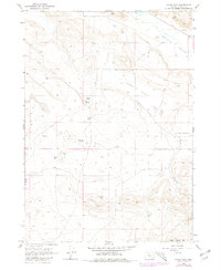
1967 Map of Adobe Flat
USGS Topo · Published 1972About this map
Adobe Flat and the surrounding high basins of Harney County are defined here by a network of isolated water sources and volcanic landforms. Mapped from 1966 aerial photography and field-checked in 1967, the landscape reveals a sparse pattern of land use typical of this high desert region. Numerous wells are scattered throughout the quadrangle, serving as critical infrastructure for the ranching operations that navigate the terrain between Virginia Valley and Anderson Valley.
Find a feature on this map
14 named features on this map. Tap any name to fly to it.
Don’t see what you’re looking for? This feature index may not catch every label — zoom into the map to look around manually.
Map Details
Editions of this 1967 Adobe Flat Map
2 editions found
Other maps of this area

1955 · Burns
USGS Topo · 1:250,000

1958 · Burns
USGS Topo · 1:250,000

1959 · Burns
USGS Topo · 1:250,000

1960 · Crane
USGS Topo · 1:62,500

1967 · Happy Valley
USGS Topo · 1:24,000

1967 · Barton Lake
USGS Topo · 1:24,000

1967 · Diamond
USGS Topo · 1:24,000

1968 · Venator
USGS Topo · 1:62,500

1972 · Circle Bar
USGS Topo · 1:24,000

1974 · Anderson Mtn
USGS Topo · 1:62,500