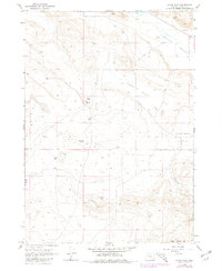
1967 Map of Adobe Flat
USGS Topo · Published 1980About this map
Adobe Flat and the surrounding high desert valleys of Harney County are defined by their sparse, water-focused geography. During this mid-century survey, the landscape was primarily utilized for cattle ranching and resource extraction, evidenced by the numerous Well sites and the Borrow Pit located in the northeast. The terrain is marked by distinctive volcanic formations such as Hat Butte, Kegler Butte, and Davison Butte, which break the level expanse of Virginia Valley and Anderson Valley. A primary seasonal water source, Kegler Lake, sits tucked between the buttes, while Little Riddle Mtn Creek drains the southern slopes near Little Riddle Mtn. The reliance on primitive transportation is visible through the mapped Jeep Trail, illustrating how remote this portion of the Oregon backcountry remained well into the 1960s.
Find a feature on this map
13 named features on this map. Tap any name to fly to it.
Don’t see what you’re looking for? This feature index may not catch every label — zoom into the map to look around manually.
Map Details
Editions of this 1967 Adobe Flat Map
2 editions found
Other maps of this area

1955 · Burns
USGS Topo · 1:250,000

1958 · Burns
USGS Topo · 1:250,000

1959 · Burns
USGS Topo · 1:250,000

1960 · Crane
USGS Topo · 1:62,500

1967 · Happy Valley
USGS Topo · 1:24,000

1967 · Barton Lake
USGS Topo · 1:24,000

1967 · Diamond
USGS Topo · 1:24,000

1967 · Adobe Flat
USGS Topo · 1:24,000

1968 · Venator
USGS Topo · 1:62,500

1972 · Circle Bar
USGS Topo · 1:24,000