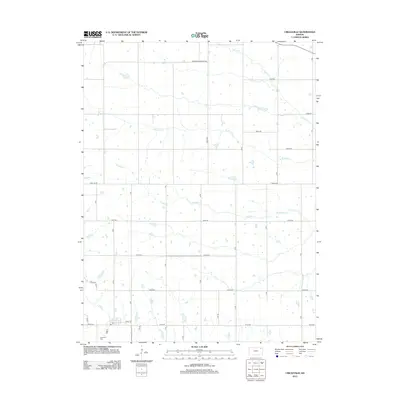
2012 Map of Circleville
USGS Topo · Published 2012About this map
Elk Creek and Straight Creek wind through this Jackson County landscape, defining the rural character of the area around the community of Circleville in the early 21st century. The map centers on a grid of section-line roads such as Parallel Rd and 270th Rd, revealing a persistent agricultural land-use pattern typical of the Kansas prairie. In the southwestern corner, the local Post Office and the Circleville Cemetery serve as the primary civic and historical anchors for the township. The drainage systems of Mosquito Creek and Spring Creek create natural breaks in the rectangular road network, illustrating how the regional hydrology influences modern property lines and transportation corridors including Wetmore-Bancroft Rd.
Find a feature on this map
19 named features on this map. Tap any name to fly to it.
Don’t see what you’re looking for? This feature index may not catch every label — zoom into the map to look around manually.
Map Details
Editions of this 2012 Circleville Map
This is the sole edition of this map. No revisions or reprints were ever made.
Other maps of this area

1888 · Hiawatha
USGS Topo · 1:125,000

1889 · Topeka
USGS Topo · 1:125,000

1894 · Topeka
USGS Topo · 1:125,000

1894 · Hiawatha
USGS Topo · 1:125,000

1950 · Kansas City
USGS Topo · 1:250,000

1954 · Kansas City
USGS Topo · 1:250,000

1956 · Kansas City
USGS Topo · 1:250,000

1960 · Kansas City
USGS Topo · 1:250,000
1960 · Holton
USGS Topo · 1:24,000
1960 · Horton NW
USGS Topo · 1:24,000