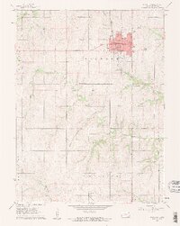
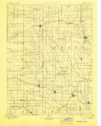
1894 Map of Hiawatha
USGS Topo · Published 1894About this map
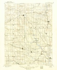
The Kickapoo Indian Reservation and Iowa Indian Reservation anchor this late-nineteenth-century landscape, providing a clear view of land allotment and tribal boundaries in northeastern Kansas. This area is defined by a dense lattice of railway systems, including the Missouri Pacific Railroad and the St. Joseph and Grand Island R.R., which facilitated the rapid growth of agricultural shipping hubs. Settlements like Hiawatha, Sabetha, and Wetmore are shown as established town grids, while smaller rail stops such as Powhattan and Netawaka illustrate the era's dependence on the steam engine. The topography is dominated by the drainages of Wolfley Creek, Grasshopper Creek, and Mulberry Creek, which carved the undulating prairie into distinct farming townships. This map captures the region just as the frontier period transitioned into a settled, rail-centric agricultural economy.
Find a feature on this map
85 named features on this map. Tap any name to fly to it.
Don’t see what you’re looking for? This feature index may not catch every label — zoom into the map to look around manually.
Map Details
Editions of this 1894 Hiawatha Map
4 editions found
Historical Maps of Hiawatha Through Time
8 maps found