
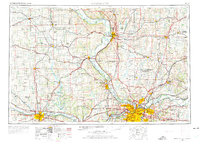
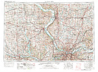
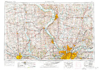
1956 Map of Kansas City
USGS Topo · Published 1967About this map
The Missouri River and Kansas River define the industrial and agricultural corridors of this mid-century survey, anchoring the major hubs of Kansas City, Topeka, and Saint Joseph. The landscape reveals a complex network of transportation and government land use, from the sprawling Fort Leavenworth Military Reservation and Kansas State Penitentiary to the Lake City Army Ammunition Plant east of Independence. This era shows the region in transition, with the expansion of the interstate system including I-70 and I-35 beginning to overlay the established rail lines of the Union Pacific RR and Atchison Topeka and Santa Fe RR. Water management is prominent through the massive Perry Reservoir and smaller recreational sites like Leavenworth County State Park, while the northern reaches maintain a rural character across the Sac and Fox-Iowa Indian Reservation and Kickapoo Indian Reservation.
Find a feature on this map
230 named features on this map. Tap any name to fly to it.
Don’t see what you’re looking for? This feature index may not catch every label — zoom into the map to look around manually.
Map Details
Editions of this 1956 Kansas City Map
4 editions found
Other maps of this area

1885 · Eskridge
USGS Topo · 1:125,000

1885 · Warrensburg
USGS Topo · 1:125,000

1885 · Atchison
USGS Topo · 1:125,000

1885 · Lawrence
USGS Topo · 1:125,000

1886 · Oskaloosa
USGS Topo · 1:125,000

1887 · Harrisonville
USGS Topo · 1:125,000

1887 · Olathe
USGS Topo · 1:125,000

1887 · Warrensburg
USGS Topo · 1:125,000

1888 · Oskaloosa
USGS Topo · 1:125,000

1888 · Atchison
USGS Topo · 1:125,000