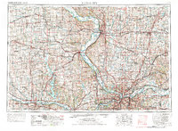
1956 Map of Kansas City
USGS Topo · Published 1976About this map
The Missouri River corridor serves as the primary artery for this mid-century landscape, carving a series of dramatic bends including Quindaro Bend and Sibley Bend. This regional study reveals the industrial and institutional foundations of the border region, where massive federal facilities like Fort Leavenworth and the Leavenworth Federal Penitentiary overlook the river valley. The infrastructure reflects a decade of rapid expansion, featuring the burgeoning Kansas City International Airport and a dense network of major transit routes including Interstate 70 and Interstate 35.
Find a feature on this map
289 named features on this map. Tap any name to fly to it.
Don’t see what you’re looking for? This feature index may not catch every label — zoom into the map to look around manually.
Map Details
Editions of this 1956 Kansas City Map
4 editions found

Other maps of this area

1885 · Eskridge
USGS Topo · 1:125,000

1885 · Warrensburg
USGS Topo · 1:125,000

1885 · Atchison
USGS Topo · 1:125,000

1885 · Lawrence
USGS Topo · 1:125,000

1886 · Oskaloosa
USGS Topo · 1:125,000

1887 · Harrisonville
USGS Topo · 1:125,000

1887 · Olathe
USGS Topo · 1:125,000

1887 · Warrensburg
USGS Topo · 1:125,000

1888 · Oskaloosa
USGS Topo · 1:125,000

1888 · Atchison
USGS Topo · 1:125,000