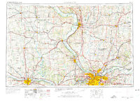
1956 Map of Kansas City
USGS Topo · Published 1975About this map
The Missouri River corridor serves as the central artery for this mid-century portrait of the Kansas-Missouri borderlands. Major urban centers at Saint Joseph, Kansas City, and Topeka are shown connected by a dense lattice of infrastructure, including the Kansas Turnpike and several prominent rail lines like the Union Pacific and Missouri Pacific. The map captures a transition in land use, where the industrial and residential expansion of Kansas City and Independence contrasts with the preserved lands of the Sac and Fox-Iowa Indian Reservation, Kickapoo Indian Reservation, and Potawatomi Indian Reservation. Notable institutional landmarks include Fort Leavenworth Military Reservation and the Kansas State Penitentiary near Leavenworth. Smaller settlements such as Sabetha, Horton, and Valley Falls dot the landscape, illustrating the regional importance of secondary rail hubs and agricultural centers during the post-war era.
Find a feature on this map
47 named features on this map. Tap any name to fly to it.
Don’t see what you’re looking for? This feature index may not catch every label — zoom into the map to look around manually.
Map Details
Editions of this 1956 Kansas City Map
4 editions found

Other maps of this area

1885 · Eskridge
USGS Topo · 1:125,000

1885 · Warrensburg
USGS Topo · 1:125,000

1885 · Atchison
USGS Topo · 1:125,000

1885 · Lawrence
USGS Topo · 1:125,000

1886 · Oskaloosa
USGS Topo · 1:125,000

1887 · Harrisonville
USGS Topo · 1:125,000

1887 · Olathe
USGS Topo · 1:125,000

1887 · Warrensburg
USGS Topo · 1:125,000

1888 · Oskaloosa
USGS Topo · 1:125,000

1888 · Atchison
USGS Topo · 1:125,000