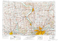
1956 Map of Kansas City
USGS Topo · Published 1976About this map
The Missouri River anchors this regional perspective, winding between the growing urban centers of Saint Joseph and the sprawling Kansas City metropolitan area. Compiled in the mid-1950s and revised in the 1970s, the map documents a transformative era of infrastructure, showing the emergence of Interstate 70 alongside the long-established Union Pacific RR. To the west, Topeka serves as the state capital anchor, while Fort Leavenworth stands as a prominent military installation overlooking the river bend. The landscape is a dense network of small agricultural towns like Atchison and Hiawatha, each with its own identified schools and cemeteries. East of the river, the Missouri side shows the residential expansion into Gladstone and Independence, alongside recreational developments such as Lake Jacomo and Lake Lotawana. This survey captures the region as it transitioned from a river-and-rail economy into the modern interstate era.
Find a feature on this map
564 named features on this map. Tap any name to fly to it.
Don’t see what you’re looking for? This feature index may not catch every label — zoom into the map to look around manually.
Map Details
Editions of this 1956 Kansas City Map
4 editions found

Other maps of this area

1885 · Eskridge
USGS Topo · 1:125,000

1885 · Warrensburg
USGS Topo · 1:125,000

1885 · Atchison
USGS Topo · 1:125,000

1885 · Lawrence
USGS Topo · 1:125,000

1886 · Oskaloosa
USGS Topo · 1:125,000

1887 · Harrisonville
USGS Topo · 1:125,000

1887 · Olathe
USGS Topo · 1:125,000

1887 · Warrensburg
USGS Topo · 1:125,000

1888 · Oskaloosa
USGS Topo · 1:125,000

1888 · Atchison
USGS Topo · 1:125,000