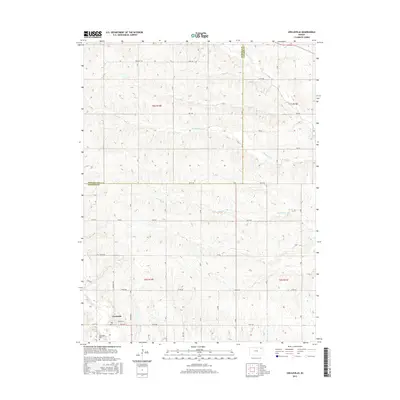
2015 Map of Circleville
USGS Topo · Published 2015About this map
Circleville serves as the primary hub of this landscape in the northern Flint Hills region, situated along the southern edge of the quadrangle. The town's grid is centered around Grant St and Mill Rd, reflecting its local development patterns. Just outside the settlement, the Circleville Cem provides a focal point for genealogical research. The surrounding terrain is defined by a dense network of drainage systems, including Mosquito Cr and Straight Cr, which carve through the land north of the town. This area marks the boundary between Nemaha Co and Jackson Co, where the landscape transitions from rolling uplands to the creek bottoms. The road system, including Bencraft Rd and 310th Rd, follows the Public Land Survey System sections, illustrating the enduring agricultural organization of the Kansas prairie.
Find a feature on this map
28 named features on this map. Tap any name to fly to it.
Don’t see what you’re looking for? This feature index may not catch every label — zoom into the map to look around manually.
Map Details
Editions of this 2015 Circleville Map
This is the sole edition of this map. No revisions or reprints were ever made.
Other maps of this area

1888 · Hiawatha
USGS Topo · 1:125,000

1889 · Topeka
USGS Topo · 1:125,000

1894 · Topeka
USGS Topo · 1:125,000

1894 · Hiawatha
USGS Topo · 1:125,000

1950 · Kansas City
USGS Topo · 1:250,000

1954 · Kansas City
USGS Topo · 1:250,000

1956 · Kansas City
USGS Topo · 1:250,000

1960 · Kansas City
USGS Topo · 1:250,000
1960 · Holton
USGS Topo · 1:24,000
1960 · Horton NW
USGS Topo · 1:24,000