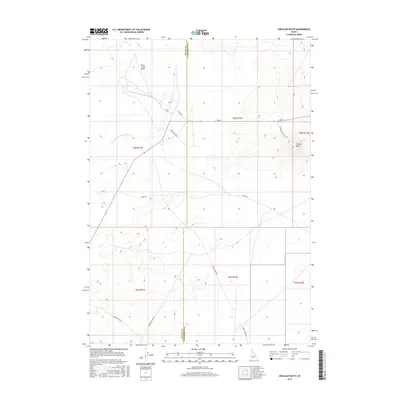
2017 Map of Circular Butte
USGS Topo · Published 2017About this map
Circular Butte rises prominently above the high desert floor in this 2017 study of the eastern Snake River Plain. The landscape is defined by its intermittent hydrology, where the Birch Creek Sinks serve as the terminal drainage for Birch Creek. This area illustrates the unique geological transition where surface waters from the northern mountains vanish into the porous basalt of the desert floor. The network of local roads, such as Snake Ave and Mc Kinley Blvd, follows the rectilinear patterns of the Public Land Survey System, cutting across the arid terrain. Traces of historical waterways are evident in the Dry Channel Big Lost River, showing the shifts in water flow across this portion of Jefferson and Butte counties. The map provides a clear view of the vast, open infrastructure of the region, including Canal Rd and the straight-line paths of E Monument Line Rd.
Find a feature on this map
19 named features on this map. Tap any name to fly to it.
Don’t see what you’re looking for? This feature index may not catch every label — zoom into the map to look around manually.
Map Details
Editions of this 2017 Circular Butte Map
This is the sole edition of this map. No revisions or reprints were ever made.
Other maps of this area

1955 · Idaho Falls
USGS Topo · 1:250,000

1958 · Idaho Falls
USGS Topo · 1:250,000

1969 · Antelope Butte
USGS Topo · 1:24,000

1969 · Circular Butte
USGS Topo · 1:24,000

1969 · Circular Butte NW
USGS Topo · 1:24,000

1969 · Richard Butte
USGS Topo · 1:24,000
1969 · Monteview
USGS Topo · 1:24,000

1969 · Big Lost River Sinks
USGS Topo · 1:24,000

1973 · Little Butte NE
USGS Topo · 1:24,000

1973 · Little Butte NW
USGS Topo · 1:24,000