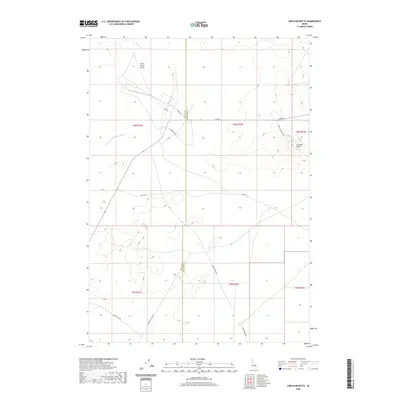
2020 Map of Circular Butte
USGS Topo · Published 2020About this map
Circular Butte dominates the eastern portion of this high desert terrain, serving as a prominent volcanic landmark on the border between Butte and Jefferson Counties. This 2020 record of the Snake River Plain illustrates a landscape defined by seasonal hydrography and irrigation infrastructure, where the Dry Channel Big Lost River and Birch Cr terminate at the Birch Creek Sinks. A grid of utility and section roads, including Mc Kinley Blvd, Snake Ave, and E Monument Line Rd, provides access across the arid flats. The map documents the persistent human engineering of this environment through features like Canal Rd, illustrating how water management and desert navigation intersect in this corner of Idaho.
Find a feature on this map
19 named features on this map. Tap any name to fly to it.
Don’t see what you’re looking for? This feature index may not catch every label — zoom into the map to look around manually.
Map Details
Editions of this 2020 Circular Butte Map
This is the sole edition of this map. No revisions or reprints were ever made.
Other maps of this area

1955 · Idaho Falls
USGS Topo · 1:250,000

1958 · Idaho Falls
USGS Topo · 1:250,000

1969 · Antelope Butte
USGS Topo · 1:24,000

1969 · Circular Butte
USGS Topo · 1:24,000

1969 · Circular Butte NW
USGS Topo · 1:24,000

1969 · Richard Butte
USGS Topo · 1:24,000
1969 · Monteview
USGS Topo · 1:24,000

1969 · Big Lost River Sinks
USGS Topo · 1:24,000

1973 · Little Butte NE
USGS Topo · 1:24,000

1973 · Little Butte NW
USGS Topo · 1:24,000