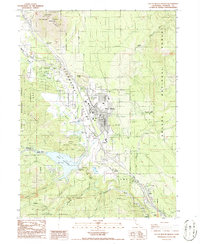
1986 Map of City of Mount Shasta
USGS Topo · Published 1986About this map
Strawberry Valley serves as the central corridor for this mid-1980s survey, where the expanding Corporation Boundary of the city of Mount Shasta meets the dense timberlands of the Shasta National Forest. The landscape is dominated by the massive volcanic profile of Black Butte and the Black Butte Summit to the north, while the upper reaches of the Sacramento River flow through the southern half of the quadrangle. The map documents significant infrastructure and recreational development, including the Box Canyon Dam which impounds the waters of Lake Siskiyou. Distinctive local landmarks such as the Mt Shasta State Fish Hatchery and several springs, including Ney Springs and Big Springs, illustrate the area's complex water network. Small settlements and industrial sites like Mott, Pioneer, and various Borrow Pits appear along the rail and road corridors, providing a detailed look at the region's mid-century economic and residential footprint.
Find a feature on this map
44 named features on this map. Tap any name to fly to it.
Don’t see what you’re looking for? This feature index may not catch every label — zoom into the map to look around manually.
Map Details
Editions of this 1986 City of Mount Shasta Map
This is the sole edition of this map. No revisions or reprints were ever made.
Other maps of this area

1886 · Shasta
USGS Topo · 1:250,000

1894 · Shasta
USGS Topo · 1:250,000

1935 · Dunsmuir
USGS Topo · 1:125,000

1948 · Weed
USGS Topo · 1:250,000

1950 · Weed
USGS Topo · 1:250,000

1954 · Shoeinhorse Mountain
USGS Topo · 1:62,500

1954 · Shasta
USGS Topo · 1:62,500

1954 · Weed
USGS Topo · 1:62,500

1954 · Dunsmuir
USGS Topo · 1:62,500

1958 · Weed
USGS Topo · 1:250,000