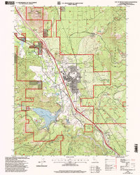
1998 Map of City of Mount Shasta
USGS Topo · Published 2003About this map
Strawberry Valley serves as the geographic heart of this late-twentieth-century survey, dominated by the urban footprint of Mount Shasta and the looming presence of Black Butte to the northwest. The landscape reflects a complex mix of protected wilderness and local infrastructure, with the Shasta Trinity National Forests surrounding the residential and commercial core. Water management is a primary feature of the valley floor, evidenced by the large expanse of Lake Siskiyou and the Box Canyon Dam controlling the Sacramento River.
Find a feature on this map
57 named features on this map. Tap any name to fly to it.
Don’t see what you’re looking for? This feature index may not catch every label — zoom into the map to look around manually.
Map Details
Editions of this 1998 City of Mount Shasta Map
This is the sole edition of this map. No revisions or reprints were ever made.
Other maps of this area

1886 · Shasta
USGS Topo · 1:250,000

1894 · Shasta
USGS Topo · 1:250,000

1935 · Dunsmuir
USGS Topo · 1:125,000

1948 · Weed
USGS Topo · 1:250,000

1950 · Weed
USGS Topo · 1:250,000

1954 · Shoeinhorse Mountain
USGS Topo · 1:62,500

1954 · Shasta
USGS Topo · 1:62,500

1954 · Weed
USGS Topo · 1:62,500

1954 · Dunsmuir
USGS Topo · 1:62,500

1958 · Weed
USGS Topo · 1:250,000