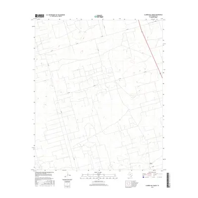
2016 Map of Clabber Hill Ranch
USGS Topo · Published 2016About this map
Clabber Hill Ranch anchors the southeastern corner of this landscape in Andrews County, where the topography is defined by subtle elevation changes and a geometric network of ranch roads. The terrain is marked by numerous depressions and intermittent water features, characteristic of the High Plains. Transport and access through the region rely on a surveyed grid of county roads, including SW 5000, SW 1001, and SW 1201. These routes intersect the open range, facilitating the movement of livestock and servicing the local ranching operations. The map illustrates the sparse, deliberate settlement pattern typical of West Texas, where large landholdings like the ranch are connected by long stretches of unpaved roadway such as SW 5900 and SW 3001.
Find a feature on this map
8 named features on this map. Tap any name to fly to it.
Don’t see what you’re looking for? This feature index may not catch every label — zoom into the map to look around manually.
Map Details
Editions of this 2016 Clabber Hill Ranch Map
This is the sole edition of this map. No revisions or reprints were ever made.
Other maps of this area

1954 · Hobbs
USGS Topo · 1:250,000

1958 · Hobbs
USGS Topo · 1:250,000

1963 · Andrews
USGS Topo · 1:24,000

1967 · North Cowden
USGS Topo · 1:24,000

1968 · Coyote Corner
USGS Topo · 1:24,000

1968 · North Cowden NW
USGS Topo · 1:24,000

1968 · Gardendale NW
USGS Topo · 1:24,000

1968 · Clabber Hill Ranch
USGS Topo · 1:24,000
1968 · Gardendale
USGS Topo · 1:24,000
1971 · Five Wells Ranch SW
USGS Topo · 1:24,000