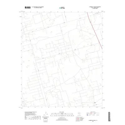
2019 Map of Clabber Hill Ranch
USGS Topo · Published 2019About this map
Clabber Hill Ranch occupies the southern reaches of this West Texas landscape in Andrews County. This high-plains terrain is defined by a dense, geometric network of local ranch and service roads, including Sw 5000, Sw 5900, and Sw 1201. The map reveals the intricate infrastructure required to manage large-scale ranching and mineral operations in a semi-arid environment. Unlike typical township and range grids, the survey lines here follow a complex, irregular pattern of land divisions and property boundaries, punctuated by small reservoirs and catchment basins that support the local cattle industry. The presence of Sw 1001 and Sw 8000 illustrates the connectivity between these remote pastures and larger regional transport corridors.
Find a feature on this map
8 named features on this map. Tap any name to fly to it.
Don’t see what you’re looking for? This feature index may not catch every label — zoom into the map to look around manually.
Map Details
Editions of this 2019 Clabber Hill Ranch Map
This is the sole edition of this map. No revisions or reprints were ever made.
Other maps of this area

1954 · Hobbs
USGS Topo · 1:250,000

1958 · Hobbs
USGS Topo · 1:250,000

1963 · Andrews
USGS Topo · 1:24,000

1967 · North Cowden
USGS Topo · 1:24,000

1968 · Coyote Corner
USGS Topo · 1:24,000

1968 · North Cowden NW
USGS Topo · 1:24,000

1968 · Gardendale NW
USGS Topo · 1:24,000

1968 · Clabber Hill Ranch
USGS Topo · 1:24,000
1968 · Gardendale
USGS Topo · 1:24,000
1971 · Five Wells Ranch SW
USGS Topo · 1:24,000