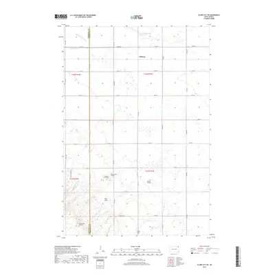
2017 Map of Claire City SW
USGS Topo · Published 2017About this map
Dahlberg sits within a landscape defined by the distinct topography of the Coteau des Prairies plateau, where the headwaters of the Little Minnesota River and several drainages begin their descent. This survey captures a rural area crossing the boundary of Marshall and Roberts Counties, characterized by its traditional township grid and a network of named watercourses and coulees. Local history and genealogy are anchored by the Mayasan Presbyterian Cem and Spring Valley Cem, which serve as prominent landmarks in an area dominated by agricultural land and natural features like Sieche Hollow and Uncle John Coulee. The presence of Indian Rte 10 and several county roads indicates the established transit routes connecting these small settlements and family farms. The terrain is notably dissected by gulches and creeks, including Myer Gulch and Munson Cr, reflecting the complex drainage patterns of this upland region.
Find a feature on this map
28 named features on this map. Tap any name to fly to it.
Don’t see what you’re looking for? This feature index may not catch every label — zoom into the map to look around manually.
Map Details
Editions of this 2017 Claire City SW Map
This is the sole edition of this map. No revisions or reprints were ever made.
Other maps of this area

1953 · Milbank
USGS Topo · 1:250,000

1958 · Milbank
USGS Topo · 1:250,000

1958 · Veblen
USGS Topo · 1:24,000

1958 · Veblen NE
USGS Topo · 1:24,000
1964 · Claire City NE
USGS Topo · 1:24,000
1964 · Claire City NW
USGS Topo · 1:24,000

1964 · Claire City
USGS Topo · 1:24,000

1964 · Claire City SW
USGS Topo · 1:24,000

1970 · Whitestone Lake
USGS Topo · 1:24,000

1970 · Sisseton
USGS Topo · 1:24,000