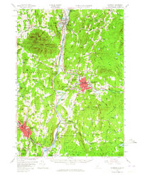
1957 Map of Claremont
USGS Topo · Published 1965About this map
The Connecticut River serves as the central artery for this mid-century portrait of the Vermont and New Hampshire borderlands, separating Windsor Co and Sullivan Co. In Vermont, the prominent profile of Mt Ascutney dominates the landscape above the village of Ascutney, while the State Prison Farm sits just north of Windsor. Across the water in New Hampshire, the industrial and civic hub of Claremont is densely mapped, showing its concentration of parochial and public education including St Marys Sch and the Jr High Sch.
Find a feature on this map
134 named features on this map. Tap any name to fly to it.
Don’t see what you’re looking for? This feature index may not catch every label — zoom into the map to look around manually.
Map Details
Editions of this 1957 Claremont Map
3 editions found
Other maps of this area

1902 · Sunapee
USGS Topo · 1:62,500

1905 · Sunapee
USGS Topo · 1:62,500

1906 · Hanover
USGS Topo · 1:62,500

1907 · Sunapee
USGS Topo · 1:62,500

1908 · Hanover
USGS Topo · 1:62,500

1911 · Woodstock
USGS Topo · 1:62,500

1913 · Woodstock
USGS Topo · 1:62,500

1926 · Claremont
USGS Topo · 1:62,500

1927 · Bellows Falls
USGS Topo · 1:48,000

1927 · Mascoma
USGS Topo · 1:62,500