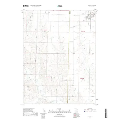
2017 Map of Clarence
USGS Topo · Published 2017About this map
Clarence serves as the primary municipal center in this section of northeastern Missouri, situated where the boundary between Macon Co and Shelby Co meets a network of local roads and state highways. The settlement of Anabel lies to the west, while the smaller community of Enterprise is located in the southeastern quadrant. The geography is defined by a dense drainage system feeding the Middle Fork Salt River, which winds along the southern edge of the quadrangle. Significant local tributaries including Bee Br, Winn Br, and Otter Cr carve through the agricultural landscape, creating the distinct topographical variations seen throughout the rural townships. Genealogists and local historians will find the Saint Patricks Cem south of Clarence, a notable landmark for tracing regional family roots in this largely rural interior.
Find a feature on this map
77 named features on this map. Tap any name to fly to it.
Don’t see what you’re looking for? This feature index may not catch every label — zoom into the map to look around manually.
Map Details
Editions of this 2017 Clarence Map
This is the sole edition of this map. No revisions or reprints were ever made.
Other maps of this area

1908 · Atlanta
USGS Topo · 1:62,500

1908 · Macon
USGS Topo · 1:62,500

1910 · Macon
USGS Topo · 1:62,500

1953 · Moberly
USGS Topo · 1:250,000

1954 · Moberly
USGS Topo · 1:250,000

1957 · Moberly
USGS Topo · 1:250,000

1958 · Lentner
USGS Topo · 1:24,000
1959 · Woodlawn
USGS Topo · 1:24,000

1960 · Moberly
USGS Topo · 1:250,000
1964 · Hagers Grove
USGS Topo · 1:24,000