
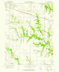
1958 Map of Lentner
USGS Topo · Published 1960About this map
Lentner sits as the primary rail-connected settlement in this mid-century Missouri landscape, positioned along the Chicago Burlington and Quincy railroad line. The map captures the agricultural and social centers of Shelby and Monroe counties just before the 1960s, documenting rural institutions such as the Oak Ridge Ch, Oak Ridge Sch, and Fairview Sch that served the surrounding farmsteads.
Find a feature on this map
16 named features on this map. Tap any name to fly to it.
Don’t see what you’re looking for? This feature index may not catch every label — zoom into the map to look around manually.
Map Details
Editions of this 1958 Lentner Map
2 editions found
Other maps of this area

1908 · Atlanta
USGS Topo · 1:62,500

1908 · Macon
USGS Topo · 1:62,500

1910 · Macon
USGS Topo · 1:62,500

1953 · Moberly
USGS Topo · 1:250,000

1954 · Moberly
USGS Topo · 1:250,000

1957 · Moberly
USGS Topo · 1:250,000

1959 · Shelbina
USGS Topo · 1:24,000
1959 · Woodlawn
USGS Topo · 1:24,000

1960 · Moberly
USGS Topo · 1:250,000
1960 · Granville
USGS Topo · 1:24,000