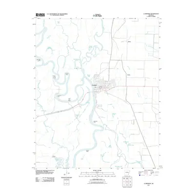
2011 Map of Clarendon
USGS Topo · Published 2011About this map
Clarendon serves as the focal point of this riverine landscape, positioned where the White River meets the confluence of the Cache River. The topography is defined by the shifting hydrology of the Delta, characterized by numerous oxbows and relic channels such as Upper Old River, First Old River, and the Crooked Point Cut-off. These water bodies, along with smaller features like Hole in the Wall and Round Pond, illustrate a complex floodplain environment that has historically dictated settlement patterns and local transit. To the east of the primary river systems, the landscape transitions into a more grid-like agricultural layout near Jeffries and the Bateman Cemetery. This area is drained by a network of creeks including Dial Creek and Knights Creek. The southern portion of the quadrangle shows the influence of water management with the Midway Lake Dam, while the presence of landmarks like Dead Man Point and Holly Tree Bend reflects a deep-seated local nomenclature tied to the river's winding path.
Find a feature on this map
45 named features on this map. Tap any name to fly to it.
Don’t see what you’re looking for? This feature index may not catch every label — zoom into the map to look around manually.
Map Details
Editions of this 2011 Clarendon Map
This is the sole edition of this map. No revisions or reprints were ever made.
Other maps of this area

1935 · Clarendon
USGS Topo · 1:62,500

1940 · Holly Grove
USGS Topo · 1:62,500

1940 · Brinkley
USGS Topo · 1:62,500

1941 · De Valls Bluff
USGS Topo · 1:62,500

1941 · Clarendon
USGS Topo · 1:62,500

1948 · Helena
USGS Topo · 1:250,000

1950 · Helena
USGS Topo · 1:250,000

1955 · Helena
USGS Topo · 1:250,000
1957 · Clarendon
USGS Topo · 1:62,500

1957 · Holly Grove
USGS Topo · 1:62,500