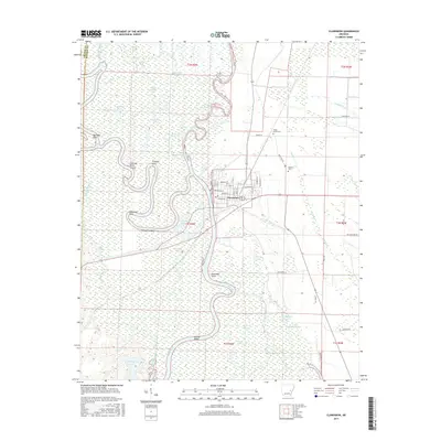
2017 Map of Clarendon
USGS Topo · Published 2017About this map
Clarendon serves as the central hub of this river-dominated landscape, situated where the Cache River flows into the meandering White River. The intricate network of waterways reflects the dynamic hydrology of the Arkansas Delta, with features like Upper Old River, First Old River, and the Crooked Point Cut-off indicating former channel paths. The surrounding wetlands are dotted with numerous named bodies of water, including Big Weidmann Lake, Passmore Lake, and Big Baptize Lake. Away from the riverbanks, the land rises slightly toward Walnut Ridge and the agricultural fields of the eastern bottoms. Local genealogy and history are preserved at Shady Grove Cem and Bateman Cem, while the town's street grid, including Washington St and Jefferson St, shows the established residential and commercial core of this riverfront community. The map's detailed labeling of river points, such as Dead Man Point and Sycamore Point, highlights the historical importance of river navigation for the region.
Find a feature on this map
69 named features on this map. Tap any name to fly to it.
Don’t see what you’re looking for? This feature index may not catch every label — zoom into the map to look around manually.
Map Details
Editions of this 2017 Clarendon Map
This is the sole edition of this map. No revisions or reprints were ever made.
Other maps of this area

1935 · Clarendon
USGS Topo · 1:62,500

1940 · Holly Grove
USGS Topo · 1:62,500

1940 · Brinkley
USGS Topo · 1:62,500

1941 · De Valls Bluff
USGS Topo · 1:62,500

1941 · Clarendon
USGS Topo · 1:62,500

1948 · Helena
USGS Topo · 1:250,000

1950 · Helena
USGS Topo · 1:250,000

1955 · Helena
USGS Topo · 1:250,000
1957 · Clarendon
USGS Topo · 1:62,500

1957 · Holly Grove
USGS Topo · 1:62,500