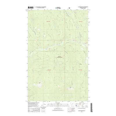
2017 Map of Clark Mountain
USGS Topo · Published 2017About this map
Kootenai National Forest dominates this section of the Purcell Mountains in northwest Montana, where the terrain is defined by the high elevations of Clark Mtn and Grizzly Mountain. This landscape is primarily shaped by its drainage systems, with the Yaak River flowing through the central portion of the quadrangle. The map reveals a high-altitude wilderness accessible by seasonal routes like Long Meadow Rd and Yaak River Rd, which follow the river valley. The region is interlaced with numerous smaller waterways, including Whitetail Cr and Pheasant Cr, that feed into the larger river system. Winter recreation and utility are evidenced by specialized trails such as the Pete Creek Snowmobile (Snow) route and the Spread Creek Snowmobile path. This modern survey provides an exact record of topographic peaks and the remote infrastructure supporting the national forest's management.
Find a feature on this map
26 named features on this map. Tap any name to fly to it.
Don’t see what you’re looking for? This feature index may not catch every label — zoom into the map to look around manually.
Map Details
Editions of this 2017 Clark Mountain Map
This is the sole edition of this map. No revisions or reprints were ever made.
Other maps of this area

1957 · Kalispell
USGS Topo · 1:250,000

1960 · Kalispell
USGS Topo · 1:250,000

1961 · Kalispell
USGS Topo · 1:250,000

1963 · Yaak
USGS Topo · 1:24,000

1963 · Sylvanite
USGS Topo · 1:24,000

1963 · Mount Baldy
USGS Topo · 1:24,000

1963 · Northwest Peak
USGS Topo · 1:24,000

1963 · Garver Mountain
USGS Topo · 1:24,000
1963 · Newton Mountain
USGS Topo · 1:24,000

1963 · Clark Mountain
USGS Topo · 1:24,000