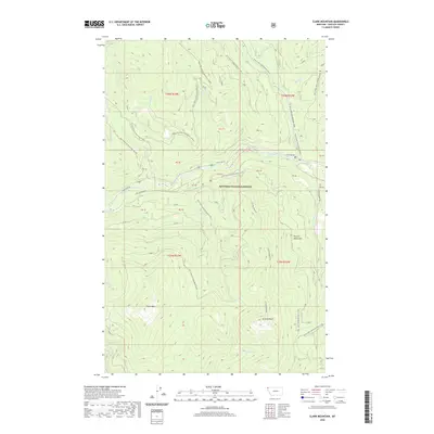
2020 Map of Clark Mountain
USGS Topo · Published 2020About this map
Clark Mtn and the surrounding peaks of the Purcell Mountains dominate this high-elevation landscape within the Kootenai National Forest. The Yaak River cuts through the central terrain, served by Yaak River Rd and Long Meadow Rd. This modern survey illustrates a landscape managed for both timber and recreation, with an extensive network of forest roads like Natl Forest Develop Road 902 Rd and dedicated winter trails including the Pete Creek Snowmobile and Upper Whitetail Snowmobile routes. Numerous drainages such as Grizzly Cr, Pheasant Cr, and Pete Cr define the watershed, flowing from prominent heights like Grizzly Mountain and Grizzly Point. The map provides a precise record of late 20th-century Forest Service infrastructure and topographic detail in this corner of Lincoln County.
Find a feature on this map
47 named features on this map. Tap any name to fly to it.
Don’t see what you’re looking for? This feature index may not catch every label — zoom into the map to look around manually.
Map Details
Editions of this 2020 Clark Mountain Map
This is the sole edition of this map. No revisions or reprints were ever made.
Other maps of this area

1957 · Kalispell
USGS Topo · 1:250,000

1960 · Kalispell
USGS Topo · 1:250,000

1961 · Kalispell
USGS Topo · 1:250,000

1963 · Yaak
USGS Topo · 1:24,000

1963 · Sylvanite
USGS Topo · 1:24,000

1963 · Mount Baldy
USGS Topo · 1:24,000

1963 · Northwest Peak
USGS Topo · 1:24,000

1963 · Garver Mountain
USGS Topo · 1:24,000
1963 · Newton Mountain
USGS Topo · 1:24,000

1963 · Clark Mountain
USGS Topo · 1:24,000