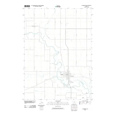
2010 Map of Clarksville
USGS Topo · Published 2010About this map
The Shell Rock River defines the landscape of Butler County in this survey, winding its way past the community of Clarksville. This area of north-central Iowa is characterized by its orderly grid of county roads, such as Raven Rd and Ridge Ave, which serve the agricultural lands between significant watercourses like Flood Creek and Dry Creek. The small settlement of Packard sits in the northwest corner, marking a quiet junction of local history.
Find a feature on this map
40 named features on this map. Tap any name to fly to it.
Don’t see what you’re looking for? This feature index may not catch every label — zoom into the map to look around manually.
Map Details
Editions of this 2010 Clarksville Map
This is the sole edition of this map. No revisions or reprints were ever made.
Other maps of this area

1954 · Waterloo
USGS Topo · 1:250,000

1955 · Waterloo
USGS Topo · 1:250,000

1971 · Shell Rock
USGS Topo · 1:24,000

1971 · Coster
USGS Topo · 1:24,000

1971 · Plainfield
USGS Topo · 1:24,000

1971 · Nashua NW
USGS Topo · 1:24,000

1971 · Clarksville
USGS Topo · 1:24,000
1971 · Nashua
USGS Topo · 1:24,000

1972 · Allison
USGS Topo · 1:24,000
1972 · Greene
USGS Topo · 1:24,000