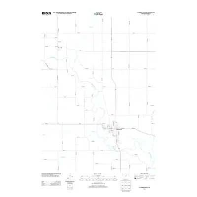
2013 Map of Clarksville
USGS Topo · Published 2013About this map
Clarksville anchors the southern portion of this Butler County landscape, situated at a major bend where the Shell Rock River meanders through the central corridor. The river's winding course is the primary geographical influence on the area's development, joined by several local tributaries including Flood Creek from the north and Dry Creek to the west. Further north, the smaller settlement of Packard sits along Packard Avenue, marking a distinct node of historical activity in an otherwise grid-patterned agricultural region. The map captures the interface between these established towns and the riparian environment, with Beaver Creek cutting across the southeastern corner. Transportation is defined by a rigorous mile-block grid of gravel and paved routes like Quail Avenue and Range Road, providing access to the fertile lands surrounding the river valley.
Find a feature on this map
56 named features on this map. Tap any name to fly to it.
Don’t see what you’re looking for? This feature index may not catch every label — zoom into the map to look around manually.
Map Details
Editions of this 2013 Clarksville Map
This is the sole edition of this map. No revisions or reprints were ever made.
Other maps of this area

1954 · Waterloo
USGS Topo · 1:250,000

1955 · Waterloo
USGS Topo · 1:250,000

1971 · Shell Rock
USGS Topo · 1:24,000

1971 · Coster
USGS Topo · 1:24,000

1971 · Plainfield
USGS Topo · 1:24,000

1971 · Nashua NW
USGS Topo · 1:24,000

1971 · Clarksville
USGS Topo · 1:24,000
1971 · Nashua
USGS Topo · 1:24,000

1972 · Allison
USGS Topo · 1:24,000
1972 · Greene
USGS Topo · 1:24,000