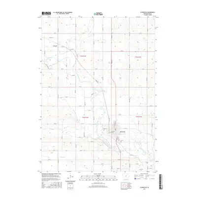
2015 Map of Clarksville
USGS Topo · Published 2015About this map
The Shell Rock River winds through this section of Butler County, creating a distinct hydrological landscape where multiple tributaries like Flood Cr and Dry Cr converge. The city of Clarksville serves as the primary hub, established along the riverbanks with a grid of residential and industrial streets. This 2015 survey reflects a landscape shaped by both its natural waterways and a rigid section-line road network, including Spring Ave and Royal Ave, which define the agricultural plots surrounding the town centers. For genealogists, the map is particularly valuable for its documentation of burial sites outside the main settlement, including Lynwood Cem, Old Cem, and the more remote Old Town Cem and Lowell Cem located to the south. To the northwest, the smaller settlement of Packard sits at the junction of Range Rd and Division St, illustrating the secondary rail and road hamlets that supported the regional farming economy.
Find a feature on this map
59 named features on this map. Tap any name to fly to it.
Don’t see what you’re looking for? This feature index may not catch every label — zoom into the map to look around manually.
Map Details
Editions of this 2015 Clarksville Map
This is the sole edition of this map. No revisions or reprints were ever made.
Other maps of this area

1954 · Waterloo
USGS Topo · 1:250,000

1955 · Waterloo
USGS Topo · 1:250,000

1971 · Shell Rock
USGS Topo · 1:24,000

1971 · Coster
USGS Topo · 1:24,000

1971 · Plainfield
USGS Topo · 1:24,000

1971 · Nashua NW
USGS Topo · 1:24,000

1971 · Clarksville
USGS Topo · 1:24,000
1971 · Nashua
USGS Topo · 1:24,000

1972 · Allison
USGS Topo · 1:24,000
1972 · Greene
USGS Topo · 1:24,000