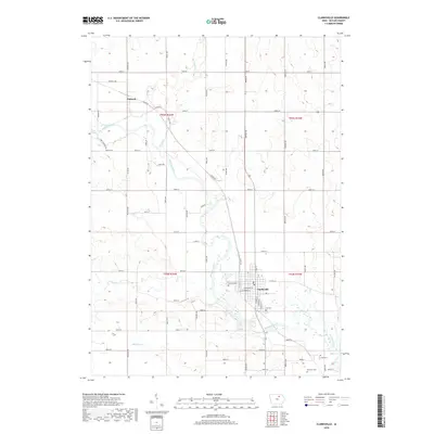
2018 Map of Clarksville
USGS Topo · Published 2018About this map
Clarksville stands as the central hub of this Butler County landscape, situated along a sharp bend of the Shell Rock River. The town's layout is well-documented, showing the local Post Office and several historic burial grounds including Lynwood Cem and the Old Cem. To the northwest, the smaller settlement of Packard sits at the junction of Range Rd and Packard Ave, serving as a secondary point of reference in this predominantly agricultural region.
Find a feature on this map
59 named features on this map. Tap any name to fly to it.
Don’t see what you’re looking for? This feature index may not catch every label — zoom into the map to look around manually.
Map Details
Editions of this 2018 Clarksville Map
This is the sole edition of this map. No revisions or reprints were ever made.
Other maps of this area

1954 · Waterloo
USGS Topo · 1:250,000

1955 · Waterloo
USGS Topo · 1:250,000

1971 · Shell Rock
USGS Topo · 1:24,000

1971 · Coster
USGS Topo · 1:24,000

1971 · Plainfield
USGS Topo · 1:24,000

1971 · Nashua NW
USGS Topo · 1:24,000

1971 · Clarksville
USGS Topo · 1:24,000
1971 · Nashua
USGS Topo · 1:24,000

1972 · Allison
USGS Topo · 1:24,000
1972 · Greene
USGS Topo · 1:24,000