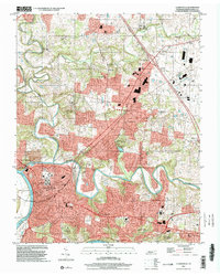
1997 Map of Clarksville
USGS Topo · Published 2002About this map
The confluence of the Cumberland River and the Red River anchors this 1997 survey of the region. By the late 1990s, the landscape shows significant suburban expansion north of the Clarksville city center, particularly around the established communities of New Providence and St Bethlehem. The map captures the complex topography surrounding the Dunbar Cave State Natural Area and the winding course of the West Fork Red River as it enters from the northwest. Educational and civic infrastructure is prominently mapped, from Austin Peay State University in the urban core to residential school sites like Broomfield Sch and Needmore Sch. Recreational spaces such as Montgomery Co Rotary Park and the Boy Scout Camp highlight the preservation of green space amidst the growing residential developments of Ashland Hills and surrounding neighborhoods.
Find a feature on this map
39 named features on this map. Tap any name to fly to it.
Don’t see what you’re looking for? This feature index may not catch every label — zoom into the map to look around manually.
Map Details
Editions of this 1997 Clarksville Map
This is the sole edition of this map. No revisions or reprints were ever made.
Other maps of this area

1944 · Clarksville
USGS Topo · 1:50,000

1950 · Guthrie
USGS Topo · 1:24,000

1951 · New Providence
USGS Topo · 1:24,000

1951 · Hammacksville
USGS Topo · 1:24,000

1951 · Clarksville
USGS Topo · 1:24,000

1951 · Oak Grove
USGS Topo · 1:24,000

1956 · Nashville
USGS Topo · 1:250,000

1957 · Henrietta
USGS Topo · 1:24,000

1957 · Sango
USGS Topo · 1:24,000

1957 · New Providence
USGS Topo · 1:24,000
Featured Places
- Clarksville, TN
- Hillview Estates, Clarksville
- Shady Bluff, Clarksville
- Swan Lake Village, Clarksville
- Spring Valley, Clarksville