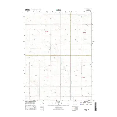
2016 Map of Clarkville
USGS Topo · Published 2016About this map
The settlement of Clarkville anchors the southeast corner of this high plains landscape, situated at the tri-county junction where Yuma, Phillips, and Logan counties meet. This agricultural region is defined by a grid of section roads like Co RD 56 and Co RD 1, which trace the legacy of the Public Land Survey System across the prairie. The terrain is marked by subtle watercourses including Coyote Creek and Patent Creek, which drain toward the northeast through the rolling hills. For those tracing local heritage, the map identifies small markers of early community life such as Bryant Cem and Rockland Cem, alongside natural landmarks like Antelope Gap. These features provide a clear view of the rural settlement patterns that have persisted in this corner of Colorado into the twenty-first century.
Find a feature on this map
37 named features on this map. Tap any name to fly to it.
Don’t see what you’re looking for? This feature index may not catch every label — zoom into the map to look around manually.
Map Details
Editions of this 2016 Clarkville Map
This is the sole edition of this map. No revisions or reprints were ever made.
Other maps of this area
1954 · Sterling
USGS Topo · 1:250,000
1958 · Sterling
USGS Topo · 1:250,000
1971 · Clarkville NE
USGS Topo · 1:24,000
1971 · Haxtun SE
USGS Topo · 1:24,000
1971 · Clarkville SE
USGS Topo · 1:24,000
1972 · Clarkville
USGS Topo · 1:24,000
1972 · New Haven
USGS Topo · 1:24,000
1972 · St Petersburg
USGS Topo · 1:24,000
1972 · Rockland
USGS Topo · 1:24,000
1972 · Lone Star
USGS Topo · 1:24,000