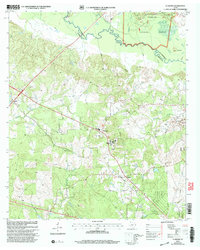
2003 Map of Clawson
USGS Topo · Published 2004About this map
Angelina National Forest dominates the northeast corner of this landscape, where the Angelina River meanders along the boundary of Nacogdoches and Angelina counties. The terrain is defined by a complex network of bayous and creeks, including Bonaldo Creek, Alazan Bayou, and Loco Bayou, which create a varied hydrologic pattern across the timberlands. This 2003 revision, based on surveys dating back to 1949, reveals a collection of rural settlements and family landmarks that have anchored the region for decades.
Find a feature on this map
27 named features on this map. Tap any name to fly to it.
Don’t see what you’re looking for? This feature index may not catch every label — zoom into the map to look around manually.
Map Details
Editions of this 2003 Clawson Map
This is the sole edition of this map. No revisions or reprints were ever made.
Other maps of this area

1949 · Lufkin
USGS Topo · 1:62,500

1949 · Clawson
USGS Topo · 1:24,000

1949 · Lufkin
USGS Topo · 1:24,000

1949 · Keltys
USGS Topo · 1:24,000

1950 · Keltys
USGS Topo · 1:24,000

1950 · Lufkin
USGS Topo · 1:24,000

1950 · Clawson
USGS Topo · 1:24,000

1950 · Redland
USGS Topo · 1:24,000

1951 · Wells
USGS Topo · 1:24,000

1951 · Wells SW
USGS Topo · 1:24,000