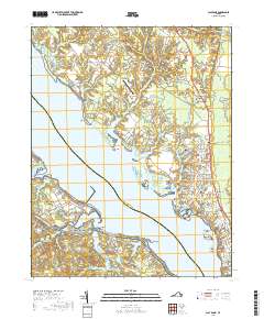
2019 Map of Clay Bank
USGS Topo · Published 2019About this map
Clay Bank and White Marsh anchor this coastal landscape along the northern bank of the York River, where numerous tidal creeks and inlets define the Gloucester County shoreline. The interior is a mix of small settlements and historical sites, including the Abingdon Cem and the grounds of the Rosewell Plantation Rd, pointing to the deep colonial roots of the region. The map shows a transition from agricultural land use to modern institutional footprints, notably with the New Quarter Farm Airport and the residential clusters around Ordinary and Clopton.
Find a feature on this map
184 named features on this map. Tap any name to fly to it.
Don’t see what you’re looking for? This feature index may not catch every label — zoom into the map to look around manually.
Map Details
Editions of this 2019 Clay Bank Map
This is the sole edition of this map. No revisions or reprints were ever made.
Other maps of this area

1906 · Williamsburg
USGS Topo · 1:62,500

1907 · Yorktown
USGS Topo · 1:62,500

1907 · Hampton
USGS Topo · 1:62,500

1916 · Mathews
USGS Topo · 1:62,500

1917 · Mathews
USGS Topo · 1:62,500

1943 · Yorktown
USGS Topo · 1:62,500

1943 · Richmond
USGS Topo · 1:250,000

1944 · Yorktown
USGS Topo · 1:24,000

1944 · Harris Grove
USGS Topo · 1:24,000

1948 · Ware Neck
USGS Topo · 1:24,000