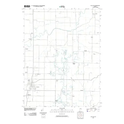
2010 Map of Clay City
USGS Topo · Published 2010About this map
Clay City serves as the primary hub of this landscape, established where local roads converge near the southern reaches of the Eel River. The settlement pattern follows the grid of the Indiana countryside, punctuated by historically named corners and small communities such as Middlebury, Smithville, and Denmark. The region is defined by the meandering path of the Eel River, which is flanked by the E Towpath Rd, a name echoing the canal era of the state's early transport history. Numerous family and community burial grounds, including the Zenor Cemetery, Red Brush Cemetery, and Liechty Cemetery, are scattered across the quadrangle, offering a detailed record of 19th and 20th-century residents. The terrain shifts from the river bottomlands into the localized relief of Happy Hollow, while landmarks like the Feederdam Bridge and Wabash Camp Ground indicate the area's long-standing connection to its waterways.
Find a feature on this map
58 named features on this map. Tap any name to fly to it.
Don’t see what you’re looking for? This feature index may not catch every label — zoom into the map to look around manually.
Map Details
Editions of this 2010 Clay City Map
This is the sole edition of this map. No revisions or reprints were ever made.
Other maps of this area

1908 · Clay City
USGS Topo · 1:48,000

1908 · Bloomfield
USGS Topo · 1:62,500

1910 · Clay City
USGS Topo · 1:62,500

1938 · Coal City
USGS Topo · 1:24,000

1940 · Jasonville
USGS Topo · 1:24,000

1948 · Coal City
USGS Topo · 1:24,000

1950 · Arney
USGS Topo · 1:24,000
1953 · Coal City
USGS Topo · 1:24,000

1953 · Indianapolis
USGS Topo · 1:250,000

1956 · Indianapolis
USGS Topo · 1:250,000