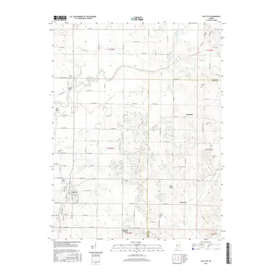
2016 Map of Clay City
USGS Topo · Published 2016About this map
Clay City serves as the focal point for this landscape along the border of Clay and Owen counties. The town is oriented around a grid of streets including Main St and Lankford St, with Goshorn Memorial Park situated at its northwestern edge. The Eel River and its major tributary system, including Conneley Ditch and Shelkett Ditch, define the drainage patterns of this agricultural region. Evidence of the area's pioneer history is preserved in a high density of rural burial grounds, such as Zenor Cem and Liechty Cem. Small crossroad communities like Denmark and Barrick Corner remain visible, linked by an extensive network of county roads. Of particular interest is the Feederdam Bridge, a significant engineering landmark located where the river intersects with E Towpath Rd and W Towpath Rd, reflecting the era of water-driven infrastructure and early transit routes through the river bottomlands.
Find a feature on this map
110 named features on this map. Tap any name to fly to it.
Don’t see what you’re looking for? This feature index may not catch every label — zoom into the map to look around manually.
Map Details
Editions of this 2016 Clay City Map
This is the sole edition of this map. No revisions or reprints were ever made.
Other maps of this area

1908 · Clay City
USGS Topo · 1:48,000

1908 · Bloomfield
USGS Topo · 1:62,500

1910 · Clay City
USGS Topo · 1:62,500

1938 · Coal City
USGS Topo · 1:24,000

1940 · Jasonville
USGS Topo · 1:24,000

1948 · Coal City
USGS Topo · 1:24,000

1950 · Arney
USGS Topo · 1:24,000
1953 · Coal City
USGS Topo · 1:24,000

1953 · Indianapolis
USGS Topo · 1:250,000

1956 · Indianapolis
USGS Topo · 1:250,000