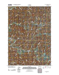
2011 Map of Clay Creek
USGS Topo · Published 2011About this map
The Siuslaw River carves a winding path through this corner of the Coast Range, defining the drainage patterns of Lane County during the early 21st century. Named tributaries such as Saleratus Creek, Pittenger Creek, and Van Curen Creek feed the river from a landscape of steep gulches and ridges. The presence of Farman Flat and Letsom Mountain provides a look at the geographic nomenclature of the region, where family names are often preserved in the topography.
Find a feature on this map
34 named features on this map. Tap any name to fly to it.
Don’t see what you’re looking for? This feature index may not catch every label — zoom into the map to look around manually.
Map Details
Editions of this 2011 Clay Creek Map
This is the sole edition of this map. No revisions or reprints were ever made.
Other maps of this area

1909 · Elmira
USGS Topo · 1:62,500

1922 · Elmira
USGS Topo · 1:62,500

1941 · Blachly
USGS Topo · 1:62,500

1942 · Elmira
USGS Topo · 1:62,500

1942 · Blachly
USGS Topo · 1:62,500

1942 · Crow
USGS Topo · 1:62,500

1942 · Roman Nose Mtn
USGS Topo · 1:62,500

1945 · Crow
USGS Topo · 1:62,500

1945 · Roman Nose Mtn
USGS Topo · 1:62,500

1953 · Salem
USGS Topo · 1:250,000