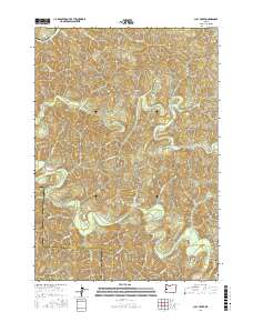
2017 Map of Clay Creek
USGS Topo · Published 2017About this map
The Siuslaw River carves a winding path through this corner of the Coast Range, defining the drainage patterns for a network of deeply recessed creeks. Central to the area is the Clay Creek Recreational Reservoir, a managed water feature that anchors local outdoor activity. The terrain is characterized by prominent elevations such as Letsom Mtn and the long spine of Haskins Ridge, which separates the many tributaries feeding the main river system.
Find a feature on this map
45 named features on this map. Tap any name to fly to it.
Don’t see what you’re looking for? This feature index may not catch every label — zoom into the map to look around manually.
Map Details
Editions of this 2017 Clay Creek Map
This is the sole edition of this map. No revisions or reprints were ever made.
Other maps of this area

1909 · Elmira
USGS Topo · 1:62,500

1922 · Elmira
USGS Topo · 1:62,500

1941 · Blachly
USGS Topo · 1:62,500

1942 · Elmira
USGS Topo · 1:62,500

1942 · Blachly
USGS Topo · 1:62,500

1942 · Crow
USGS Topo · 1:62,500

1942 · Roman Nose Mtn
USGS Topo · 1:62,500

1945 · Crow
USGS Topo · 1:62,500

1945 · Roman Nose Mtn
USGS Topo · 1:62,500

1953 · Salem
USGS Topo · 1:250,000