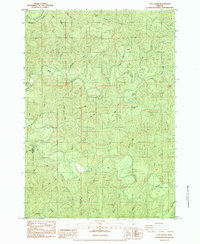
1984 Map of Clay Creek
USGS Topo · Published 1984About this map
The Siuslaw River winds through this section of the Oregon Coast Range, marking a landscape defined by its complex drainage network and early recreational development. The 1984 survey highlights the Clay Creek Recreation Site near the center of the quadrangle, situated where Clay Creek meets the river. This area, straddling the Douglas Co and Lane Co line, shows a terrain heavily shaped by timber and water, with features like Farman Flat and the small settlement of Esmond providing points of human activity amidst the dense topography. Numerous creeks with distinctive local names, such as Potato Patch Cr and Saleratus Creek, suggest the era of early homesteading and resource extraction, reinforced by the presence of a Quarry and various trails. The map serves as a detailed record of the Siuslaw watershed before later forest management shifts, capturing the precise locations of family-named landmarks like Bill Lewis Creek and Haskins Creek.
Find a feature on this map
36 named features on this map. Tap any name to fly to it.
Don’t see what you’re looking for? This feature index may not catch every label — zoom into the map to look around manually.
Map Details
Editions of this 1984 Clay Creek Map
This is the sole edition of this map. No revisions or reprints were ever made.
Other maps of this area

1909 · Elmira
USGS Topo · 1:62,500

1922 · Elmira
USGS Topo · 1:62,500

1941 · Blachly
USGS Topo · 1:62,500

1942 · Elmira
USGS Topo · 1:62,500

1942 · Blachly
USGS Topo · 1:62,500

1942 · Crow
USGS Topo · 1:62,500

1942 · Roman Nose Mtn
USGS Topo · 1:62,500

1945 · Crow
USGS Topo · 1:62,500

1945 · Roman Nose Mtn
USGS Topo · 1:62,500

1953 · Salem
USGS Topo · 1:250,000