
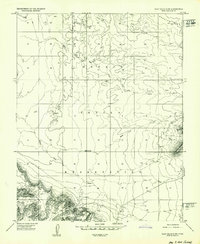
1952 Map of Clay Hills 4 SW
USGS Topo · Published 1952About this map
The Goulding Trading Post and its adjacent Landing Strip serve as focal points in this 1952 topographic study of the high desert borderlands. Located within the Navajo Indian Reservation, the landscape is defined by massive landforms like Douglas Mesa and prominent monoliths such as Mitchell Butte. This map was produced during a period of active resource exploration in the Colorado Plateau, evidenced by the presence of the Skyline Mine tucked against the southern mesa.
Find a feature on this map
19 named features on this map. Tap any name to fly to it.
Don’t see what you’re looking for? This feature index may not catch every label — zoom into the map to look around manually.
Map Details
Editions of this 1952 Clay Hills 4 SW Map
2 editions found
Other maps of this area

1883 · Marsh Pass
USGS Topo · 1:250,000

1886 · Henry Mountains
USGS Topo · 1:250,000

1892 · Marsh Pass
USGS Topo · 1:250,000

1892 · Henry Mountains
USGS Topo · 1:250,000

1952 · Clay Hills 3 SE
USGS Topo · 1:24,000

1952 · Agathla Peak 1 NW
USGS Topo · 1:24,000

1952 · Boot Mesa
USGS Topo · 1:62,500

1952 · Clay Hills 4 SE
USGS Topo · 1:24,000

1952 · Agathla Peak 1 NE
USGS Topo · 1:24,000

1952 · Agathla Peak 2 NE
USGS Topo · 1:24,000