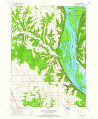
1962 Map of Clayton
USGS Topo · Published 1964About this map
The Mississippi River creates a dynamic border between Iowa and Wisconsin, defining the landscape where the Wisconsin River joins the main channel. Along the western bluffs, the Effigy Mounds National Monument and Pikes Peak State Park overlook a complex network of backwaters, including Johnsons Slough and Wyalusing Slough. This mid-century survey illustrates a river-focused economy and geography, with the Chicago Milwaukee St Paul and Pacific railroad hugging the Iowa shoreline through the town of Clayton. Across the water in Wisconsin, the village of Wyalusing sits at the edge of Wyalusing State Park. The interior of Clayton County reveals a more rural character, marked by the First Evangelical Ch, Norwegian Ch, and numerous steep drainages like Sny Magill Creek and Buck Creek.
Find a feature on this map
36 named features on this map. Tap any name to fly to it.
Don’t see what you’re looking for? This feature index may not catch every label — zoom into the map to look around manually.
Map Details
Editions of this 1962 Clayton Map
3 editions found
Other maps of this area

1902 · Elkader
USGS Topo · 1:125,000

1903 · Waukon
USGS Topo · 1:125,000

1929 · Prairie Du Chien
USGS Topo · 1:62,500

1932 · Prairie Du Chien
USGS Topo · 1:62,500

1958 · La Crosse
USGS Topo · 1:250,000

1959 · Dubuque
USGS Topo · 1:250,000

1961 · Dubuque
USGS Topo · 1:250,000

1961 · La Crosse
USGS Topo · 1:250,000

1962 · Dubuque
USGS Topo · 1:250,000

1962 · Clayton
USGS Topo · 1:24,000