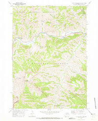
1970 Map of Clayton Mountain
USGS Topo · Published 1973About this map
The North Fork Shoshone River carves a deep valley through this corner of the Shoshone National Forest, serving as the primary corridor for travel and recreation in the early 1970s. Historical and cultural markers are prominent along the southern bank, including the Mummy Cave archeological site and a Firefighter Monument near Blackwater Creek. The landscape is defined by its transition between protected wilderness areas, with the North Absaroka Wilderness to the north and the Washakie Wilderness to the south. Along the river, a string of established recreation sites like the Rex Hale Campground and Clearwater Picnic Area demonstrate the area's importance for public access. High-elevation landmarks such as Clayton Mountain and Double Mountain anchor the terrain, while numerous drainage systems like June Creek and Elk Fork feed into the main river channel.
Find a feature on this map
28 named features on this map. Tap any name to fly to it.
Don’t see what you’re looking for? This feature index may not catch every label — zoom into the map to look around manually.
Map Details
Editions of this 1970 Clayton Mountain Map
This is the sole edition of this map. No revisions or reprints were ever made.
Other maps of this area

1893 · Ishawooa
USGS Topo · 1:125,000

1895 · Ishawooa
USGS Topo · 1:125,000

1896 · Crandall Creek
USGS Topo · 1:125,000

1899 · Crandall
USGS Topo · 1:125,000

1899 · Ishawooa
USGS Topo · 1:125,000

1955 · Cody
USGS Topo · 1:250,000

1956 · Sunlight Peak
USGS Topo · 1:62,500

1956 · Dead Indian Peak
USGS Topo · 1:62,500

1958 · Cody
USGS Topo · 1:250,000

1962 · Cody
USGS Topo · 1:250,000