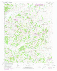
1966 Map of Clayton
USGS Topo · Published 1981About this map
The hills and creek valleys of northern Tennessee are documented here during the mid-1960s, a landscape defined by the drainage of Reelfoot Creek and North Reelfoot Creek. The small community of Clayton serves as a central point, surrounded by a network of rural settlements including Crystal, Fremont, and Dixie. The presence of the County Home and the Old Republican Sch suggests a well-established social fabric, while multiple churches like Antioch Ch and Bethel Ch anchor the local neighborhoods. High points like Mathis Hill and Logan Hill overlook a terrain marked by small-scale resource extraction at various Gravel Pit locations. The map illustrates a rural transition, showing the original locations of Old Fremont alongside newer developments near Englewood Lake.
Find a feature on this map
62 named features on this map. Tap any name to fly to it.
Don’t see what you’re looking for? This feature index may not catch every label — zoom into the map to look around manually.
Map Details
Editions of this 1966 Clayton Map
2 editions found
Other maps of this area

1925 · Reelfoot Lake
USGS Topo · 1:62,500

1939 · Reelfoot Lake
USGS Topo · 1:62,500

1939 · Hickman
USGS Topo · 1:62,500

1939 · Bayouville
USGS Topo · 1:62,500

1950 · Obion
USGS Topo · 1:24,000

1950 · Rives
USGS Topo · 1:24,000

1951 · Obion
USGS Topo · 1:24,000

1951 · Rives
USGS Topo · 1:24,000

1951 · Cayce
USGS Topo · 1:24,000

1951 · Bondurant
USGS Topo · 1:24,000