1944 Map of Clayton
USGS Topo · Published 1944About this map
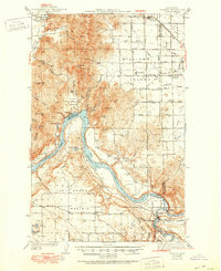
Long Lake dominates the central landscape of this 1939 survey, where the Spokane River and Little Spokane River converge near the hydroelectric site at Nine-Mile Falls. The settlement of Clayton serves as a primary hub in the northeast, connected to the wider region by the Great Northern railroad line. This area reflects a mid-century rural economy defined by scattered homesteads like Haines Ranch and communal gathering points such as the Grange Hall and Happy Valley Ch. Education is localized through a network of rural schoolhouses, including Williams Valley Sch, Burroughs Sch, and Four Mound Sch, which served the families working the surrounding prairies. The northern border reaches the Spokane Indian Reservation, while numerous peaks like Scoop Mtn and Dunns Mtn break the flat expanses of Four Mound Prairie and Walkers Prairie.
Find a feature on this map
53 named features on this map. Tap any name to fly to it.
Don’t see what you’re looking for? This feature index may not catch every label — zoom into the map to look around manually.
Map Details
Editions of this 1944 Clayton Map
2 editions found
Historical Maps of Spokane County Through Time
4 maps found