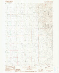
1990 Map of Clear Creek Ranch
USGS Topo · Published 1990About this map
Grass Valley and the western slopes of the Sonoma Range dominate this 1990 provisional study, marking the high-desert boundary between Pershing and Humboldt Counties. The landscape is defined by the transition from the broad, arid valley floor to the steep drainages of Grand Trunk Canyon and Washoke Canyon. Water management is central to the area's utility, evidenced by the presence of Clear Creek Ranch and isolated water sources like Turner Well and the Lower Grand Trunk Reservoir. Evidence of early or exploratory industry appears in the form of several Prospects and a Shaft located along the mountain flanks. These features, along with scattered Corrals and numerous Gravel Pits, suggest an economy balanced between ranching and mineral exploration in the Nevada interior.
Find a feature on this map
19 named features on this map. Tap any name to fly to it.
Don’t see what you’re looking for? This feature index may not catch every label — zoom into the map to look around manually.
Map Details
Editions of this 1990 Clear Creek Ranch Map
This is the sole edition of this map. No revisions or reprints were ever made.
Other maps of this area

1932 · Sonoma Range
USGS Topo · 1:250,000

1939 · Sonoma Range
USGS Topo · 1:250,000

1955 · Winnemucca
USGS Topo · 1:250,000

1958 · Winnemucca
USGS Topo · 1:250,000

1958 · Winnemucca
USGS Topo · 1:62,500

1958 · Rose Creek
USGS Topo · 1:62,500

1961 · Leach Hot Springs
USGS Topo · 1:62,500

1961 · Dun Glen
USGS Topo · 1:62,500

1962 · Winnemucca
USGS Topo · 1:250,000
1982 · Rose Creek Mtn
USGS Topo · 1:24,000