
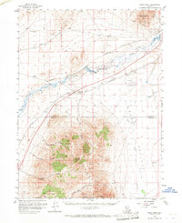
1958 Map of Rose Creek
USGS Topo · Published 1960About this map
Humboldt River defines the central corridor of this Nevada landscape, where the paths of the Southern Pacific and Western Pacific railroads converge near the small settlement of Rose Creek. To the north, Winnemucca Mountain rises above the valley floor, while the southern half of the map is dominated by the high peaks of the Sonoma Range, including Dun Glen Peak and Auld Lang Syne Peak. This 1958 survey captures a high-desert region at a crossroads of transportation and extraction, showing the proximity of the Winnemucca Airport to industrial features like the Auburn Mine and various shafts and tunnels tucked into the canyons. The map also delineates the border between Humboldt Co and Pershing Co, tracing a transition from the riparian flats of Grass Valley into the steep, spring-fed drainages of White Horse Canyon and Cedar Canyon.
Find a feature on this map
35 named features on this map. Tap any name to fly to it.
Don’t see what you’re looking for? This feature index may not catch every label — zoom into the map to look around manually.
Map Details
Editions of this 1958 Rose Creek Map
2 editions found
Other maps of this area

1882 · Paradise
USGS Topo · 1:250,000

1886 · Disaster
USGS Topo · 1:250,000

1893 · Paradise
USGS Topo · 1:250,000

1893 · Disaster
USGS Topo · 1:250,000

1931 · Lovelock
USGS Topo · 1:250,000

1932 · Sonoma Range
USGS Topo · 1:250,000

1935 · Lovelock
USGS Topo · 1:250,000

1939 · Sonoma Range
USGS Topo · 1:250,000

1939 · Eugene Mountains Area
USGS Topo · 1:62,500

1942 · Eugene Mountains Area
USGS Topo · 1:62,500