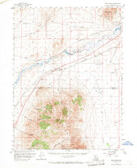
1958 Map of Rose Creek
USGS Topo · Published 1968About this map
The Humboldt River corridor serves as the primary artery through this Great Basin landscape, where the Western Pacific and Southern Pacific railroads parallel its course toward the northwest. The small settlement of Rose Creek stands near the river, while the landing strips of the Winnemucca Airport and a nearby Airway Beacon reflect mid-century aviation infrastructure in the desert.
Find a feature on this map
28 named features on this map. Tap any name to fly to it.
Don’t see what you’re looking for? This feature index may not catch every label — zoom into the map to look around manually.
Map Details
Editions of this 1958 Rose Creek Map
2 editions found

Other maps of this area

1882 · Paradise
USGS Topo · 1:250,000

1886 · Disaster
USGS Topo · 1:250,000

1893 · Paradise
USGS Topo · 1:250,000

1893 · Disaster
USGS Topo · 1:250,000

1931 · Lovelock
USGS Topo · 1:250,000

1932 · Sonoma Range
USGS Topo · 1:250,000

1935 · Lovelock
USGS Topo · 1:250,000

1939 · Sonoma Range
USGS Topo · 1:250,000

1939 · Eugene Mountains Area
USGS Topo · 1:62,500

1942 · Eugene Mountains Area
USGS Topo · 1:62,500