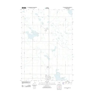
2012 Map of Clear Lake North
USGS Topo · Published 2012About this map
Glacial prairie potholes and interconnected wetlands dominate this portion of Deuel County, centered on the Coteau des Prairies. North Coteau Lake, South Coteau Lake, and East Coteau Lake form a central cluster of water bodies, reflecting the distinct topography of the region. The small community of Altamont sits to the north, while the northern outskirts of the county seat are visible at Clear Lake near the southern boundary. This 2012 survey illustrates a landscape of agricultural section lines and localized infrastructure, including the Clear Lake Municipal Airport and the local Po. The drainage pattern is defined by features like Monighan Cr and isolated basins such as Lake Alice and Ketchum Lake, which illustrate the post-glacial hydrologic network of eastern South Dakota.
Find a feature on this map
39 named features on this map. Tap any name to fly to it.
Don’t see what you’re looking for? This feature index may not catch every label — zoom into the map to look around manually.
Map Details
Editions of this 2012 Clear Lake North Map
This is the sole edition of this map. No revisions or reprints were ever made.
Other maps of this area

1953 · Watertown
USGS Topo · 1:250,000

1958 · Watertown
USGS Topo · 1:250,000

1970 · Brandt
USGS Topo · 1:24,000

1970 · Bemis
USGS Topo · 1:24,000

1970 · Clear Lake South
USGS Topo · 1:24,000

1970 · Goodwin
USGS Topo · 1:24,000

1970 · Estelline NE
USGS Topo · 1:24,000

1973 · Tunerville
USGS Topo · 1:24,000
1973 · Lake Francis
USGS Topo · 1:24,000
1973 · Clear Lake NE
USGS Topo · 1:24,000