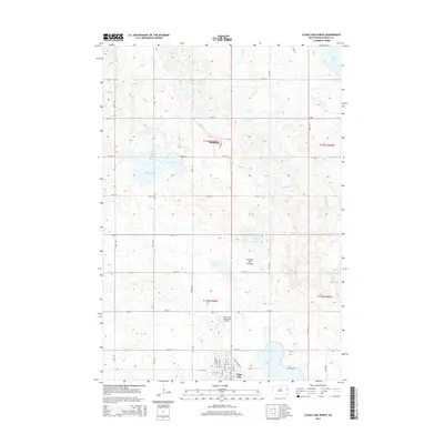
2015 Map of Clear Lake North
USGS Topo · Published 2015About this map
Coteau des Prairies defines the rolling topography of this Deuel County landscape, where glacial depressions have formed a dense cluster of water bodies. The settlement of Altamont sits in the northern half of the quadrangle, while the city of Clear Lake anchors the southern edge near its namesake Clear Lake. This 2015 survey illustrates a rural South Dakota environment shaped by modern infrastructure, including the Clear Lake Municipal Airport and a strictly defined grid of range roads like 475th Ave and 180th St. Water is the dominant geographic feature, ranging from the large expanse of Lake Alice in the northeast to the interconnected chain of North Coteau Lake, East Coteau Lake, and South Coteau Lake in the west. These lakes, alongside smaller basins like Ketchum Lake and Lake Sutton, suggest a landscape where land use is dictated by the natural drainage of Monighan Cr.
Find a feature on this map
40 named features on this map. Tap any name to fly to it.
Don’t see what you’re looking for? This feature index may not catch every label — zoom into the map to look around manually.
Map Details
Editions of this 2015 Clear Lake North Map
This is the sole edition of this map. No revisions or reprints were ever made.
Other maps of this area

1953 · Watertown
USGS Topo · 1:250,000

1958 · Watertown
USGS Topo · 1:250,000

1970 · Brandt
USGS Topo · 1:24,000

1970 · Bemis
USGS Topo · 1:24,000

1970 · Clear Lake South
USGS Topo · 1:24,000

1970 · Goodwin
USGS Topo · 1:24,000

1970 · Estelline NE
USGS Topo · 1:24,000

1973 · Tunerville
USGS Topo · 1:24,000
1973 · Lake Francis
USGS Topo · 1:24,000
1973 · Clear Lake NE
USGS Topo · 1:24,000