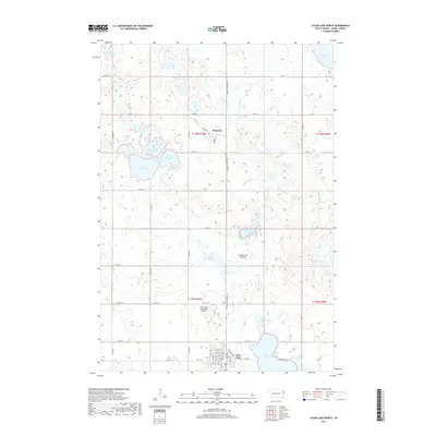
2017 Map of Clear Lake North
USGS Topo · Published 2017About this map
Coteau des Prairies defines the geography of this Deuel County landscape, characterized by a dense concentration of glacial wetlands and prairie lakes. The northern reach of the city of Clear Lake and the smaller settlement of Altamont serve as the primary hubs of activity, linked by S Dakota Highway 15. The map reveals a highly structured rural grid system, with roads like Co Rd 515 and 181st St navigating around significant water bodies such as North Coteau Lake, South Coteau Lake, and Lake Sutton. The presence of the Clear Lake Municipal Airport just north of the city limits illustrates the modern infrastructure integrated into this traditionally agricultural region. Genealogists and local historians can trace the specific township and range boundaries, including t116n r49w and t115n r49w, which continue to organize the land south of Lake Alice.
Find a feature on this map
33 named features on this map. Tap any name to fly to it.
Don’t see what you’re looking for? This feature index may not catch every label — zoom into the map to look around manually.
Map Details
Editions of this 2017 Clear Lake North Map
This is the sole edition of this map. No revisions or reprints were ever made.
Other maps of this area

1953 · Watertown
USGS Topo · 1:250,000

1958 · Watertown
USGS Topo · 1:250,000

1970 · Brandt
USGS Topo · 1:24,000

1970 · Bemis
USGS Topo · 1:24,000

1970 · Clear Lake South
USGS Topo · 1:24,000

1970 · Goodwin
USGS Topo · 1:24,000

1970 · Estelline NE
USGS Topo · 1:24,000

1973 · Tunerville
USGS Topo · 1:24,000
1973 · Lake Francis
USGS Topo · 1:24,000
1973 · Clear Lake NE
USGS Topo · 1:24,000