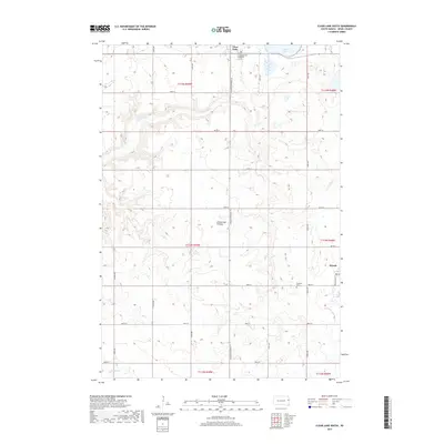
2017 Map of Clear Lake South
USGS Topo · Published 2017About this map
Coteau des Prairies, a vast plateau rising above the surrounding plains, dominates the central landscape of this Deuel County survey. The town of Brandt sits near the eastern edge, while the southern outskirts of Clear Lake appear at the northern margin, anchored by the Lakeview Cem. The terrain is defined by a dense network of sectional roads, including S Dakota Highway 15 and Washington St, which cut across the high prairie land. Water features like Hidewood Cr and Bullhead Run wind through the township sections, illustrating the drainage patterns of this elevated region. Local history is preserved in sites such as Highland Cem, tucked away in the eastern reaches of the quadrangle. The map reveals the meticulous agricultural grid system of the late 20th century, where named avenues like 473rd Ave through 478th Ave provide a structured framework for the rural homesteads and farms scattered across the Coteau.
Find a feature on this map
31 named features on this map. Tap any name to fly to it.
Don’t see what you’re looking for? This feature index may not catch every label — zoom into the map to look around manually.
Map Details
Editions of this 2017 Clear Lake South Map
This is the sole edition of this map. No revisions or reprints were ever made.
Other maps of this area

1953 · Watertown
USGS Topo · 1:250,000

1958 · Watertown
USGS Topo · 1:250,000

1970 · Brandt
USGS Topo · 1:24,000

1970 · Bemis
USGS Topo · 1:24,000

1970 · Astoria
USGS Topo · 1:24,000

1970 · Clear Lake South
USGS Topo · 1:24,000

1970 · Estelline SE
USGS Topo · 1:24,000

1970 · Estelline NE
USGS Topo · 1:24,000

1970 · Toronto
USGS Topo · 1:24,000
1973 · Lake Francis
USGS Topo · 1:24,000