
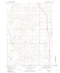
1970 Map of Estelline SE
USGS Topo · Published 1972About this map
The Big Sioux River anchors the southwestern corner of this landscape, which straddles the boundary between Deuel and Brookings counties. In the early 1970s, the region was defined by a transition in its transportation network, notably including a large Proposed Location for a new roadway cutting through the northern townships. The small community of Johnsonville sits directly on the county line, while the Chicago and Northwestern railroad tracks run along the western edge of the quadrangle. Local genealogy is supported by the location of the St John Cem and a rural Townhall. The terrain is characterized by a series of creeks and runs, such as Bullhead Run and Peg Munky Run, which drain the open farmland and prairie. Several active Gravel Pits are documented, reflecting the local extraction industry of the era.
Find a feature on this map
16 named features on this map. Tap any name to fly to it.
Don’t see what you’re looking for? This feature index may not catch every label — zoom into the map to look around manually.
Map Details
Editions of this 1970 Estelline SE Map
2 editions found
Other maps of this area

1953 · Watertown
USGS Topo · 1:250,000

1958 · Watertown
USGS Topo · 1:250,000

1968 · Brookings NE
USGS Topo · 1:24,000

1968 · Bruce
USGS Topo · 1:24,000

1969 · Dempster
USGS Topo · 1:24,000

1970 · White
USGS Topo · 1:24,000

1970 · Clear Lake South
USGS Topo · 1:24,000

1970 · Estelline
USGS Topo · 1:24,000

1970 · Estelline NE
USGS Topo · 1:24,000

1970 · Toronto
USGS Topo · 1:24,000